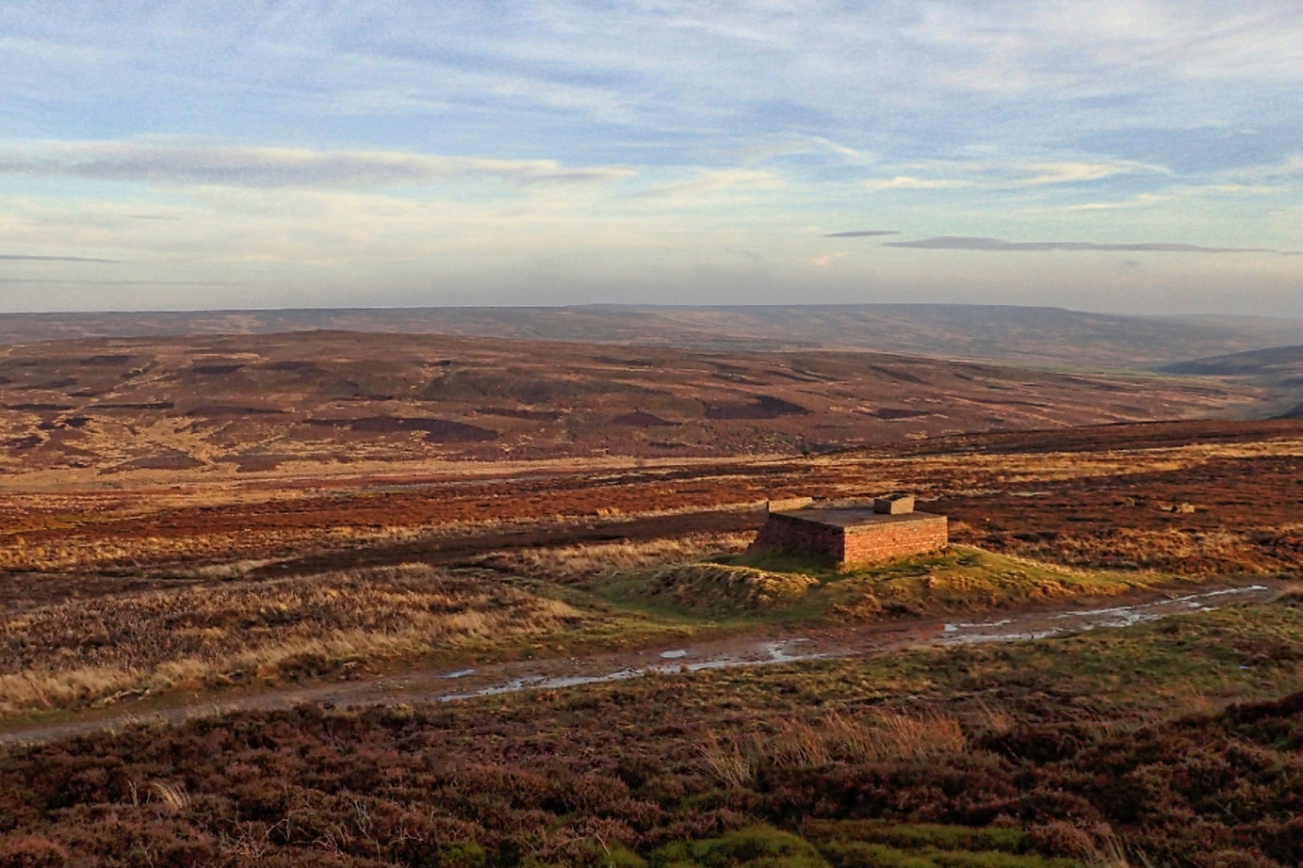
Winter 1942. A platoon of RAF personnel prepare for a long night in a brick and concrete bunker by the side of Percy Rigg on Great Ayton Moor. During the day they have been maintaining an extensive system of ditches and tanks on the moor below filling them with oily rags and fuel. Covering an area of about four acres, when lit they would resemble a burning town that would hopefully attract the attention of German bombers.
The industries of Teesside were a target for German bombing raids as were other towns and cities throughout the country. In August Middlesbrough Railway station had been hit. With the increased use of incendiary bombs a network of decoy sites was established around each town. They were called Special Fires, or ‘SF’, later to become Operation Starfish. When the first bombs were dropped on area the decoys were electrically ignited to trick subsequent bomber waves into dropping their load on the unpopulated moors. The recipe was quite sophisticated. As well as simple oily rags, diesel and paraffin were released onto coke or coal followed by water. This caused a virtual explosion of fire and steam, looking like a burning town. Other sites within the Teesside Starfish were at Osmotherley, Errington, Sneaton and Newton Bewley.
Once alight the men on Great Ayton Moor, would retire to the bunker and hope that if the German planes were indeed tricked into dropping their bombs their aim was good. The fires a mere few hundred yards away. I don’t suppose the bunker would take a direct hit. Nationwide it is said the decoy sites saved 2,500 lives although there is no evidence of any bombs actually being dropped on Great Ayton Moor. But if you do come across a tubular shaped metal object take care, it could be an unexploded bomb.

Interesting, I’ve searched the hillside below the bunker a few times for remains of the decoy itself but found nothing. However your piece inspired me to do a bit of ‘Googling’ where I found that the decoy itself was actually 640m to the south-east, centred at NZ 60762 11837 which is near Percy Cross (presumably the decoy was between the cross site and the iron age hut site to the east of the road). Apparently the earthworks of the decoy were apparent on RAF photos taken in 1946 but are no longer visible on aerial photos.
The nearest bomb craters are on Commondale Moor about 2 miles away (NZ 63580 11423 & NZ 63751 11377). Given that these are the only 2 I suspect they were just random jettisoned bombs. I know there was also a searchlight site where the Kildale – Commondale road crosses Sleddale Beck.
You mention the decoy at Sneaton south of Whitby, this was definitely in use and fairly successful as Google Earth shows the moors around are littered with bomb craters in an area bounded by the Lyke Wake Walk to the south and the A169 to the west with a few craters even off towards Goathland.
LikeLike
Thanks for that info., John. I must admit I was under the impression the decoy used trenches on the moor below the bunker. There are certainly humps and bumps there. Your location and the two bomb craters will give me the excuse to head over that way sometime. Mick
LikeLike
Mick,
Yes I’d always imagined that the decoy site itself was immediately below the bunker until I came across the Pastscape record on the Historic England site. Apologies for the ridiculous URL below.
http://www.pastscape.org.uk/hob.aspx?hob_id=1469768&sort=2&rational=m&recordsperpage=60&maplat=54.49850000&maplong=-1.06480000&mapisa=1000&mapist=ll&mapilo=-1.0648&mapila=54.4985&mapiloe=w&mapilan=n&mapios=NZ605118&mapigrn=511881&mapigre=460560&mapipc=#
LikeLike
Thanks for that , John.
LikeLike