Holy Well Gill

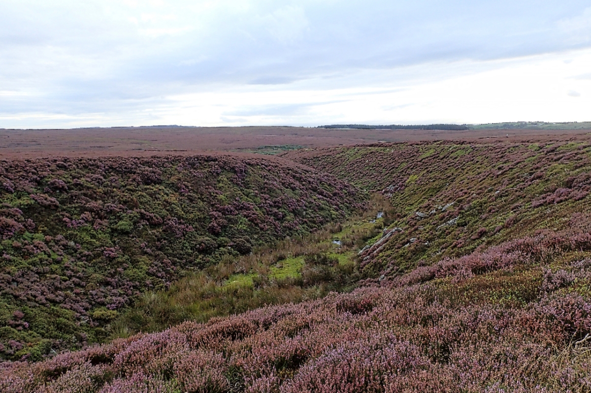
It must have needed a torrent of water to have carved this gill on Pamperdale Moor near Osmotherley. Certainly not water from the spring mapped as Holy Well and situated way down the gill not far to its junction with Crabdale Beck. The “spring” in the photo, higher up, doesn’t even qualify with an Ordnance Survey symbol. It’s just a sodden patch of chalybeate stained moss. Behind me the now dry gill continues upwards culminating in a notch on Stoney Ridge with Scugdale. And there lies the clue, for at the time of the last ice age Scugdale was dammed by the glacier and was full to the brim with water. But at some time the narrow ridge gave way releasing millions of gallons of water from Lake Scugdale and carving the gill.

Holy Well Gill Map

Kempswithen

With low cloud shrouding the North York Moors I had to dig into my bank of “bad weather” ideas. Earlier this year I recalled seeing a large new sandstone “PRIVATE NO ACCESS” sign which I thought a bit over the top. So I headed for Kempswithen, the site of a 18th-century agricultural experiment but now under intensive management for grouse shooting. But the stone had disappeared, or had my navigation let me down. A hardcore base suggests it could have been here. Instead, there was a new small sign:

“NO FOOTPATH
NO BIKES
NO DOGS”

Now, no bikes I can understand, no dogs too but no footpath! Technically it’s probably correct but this is Open Access Land over which we have the freedom to roam. Clearly, it is intended to intimidate walkers into keeping away.

On the way back I took in Percy Rigg over Kildale Moor and came across the missing sandstone “PRIVATE NO ACCESS” sign. Or its twin. Maybe I’m not going doolally after all. I just had to take a photo in case it moves again. Way over the top. The siting of this stone is actually on the boundary of Open Access Land which is to the right in the photo below. To its left is a small area of heather moorland which somehow escaped Open Access designation. An anomaly. Either way, the intention is clearly to discourage walkers from enjoying their freedom to roam. They’re a red rag to a bull to me.

No footpath sign, Kildale Moor

Kempswithen map

Hambleton Street

The ancient drovers’ route along the western edge of the North York Moors. A route that probably has been used since prehistory. The name “street” implies Roman usage and it’s mentioned by name in a document of 1577. Traffic peaked in the 17th and 18th centuries when herds of cattle were driven from Scotland to markets at Malton and York many eventually destined for London. Covering between 9 and 10 miles a day the herds of Galloway and West Highland cattle, up to 300 strong, needed a “stance” to graze for a day or so to recover for the next leg of their journey. One such stance was Limekiln House inn, the remains of which are barely discernible today in the dip opposite the wall junction, the oolite limestone providing good pasture around. The limestone was also of good enough quality for burning to produce lime and was extensively quarried along the street, providing another source of income and the name of the inn. By the 19th century, the railways had killed off the cattle droves and Limekiln House was deserted by 1897, the last licensee being Mary Kendall who “retired” to a farm in Ryedale. Today the route forms part of the Cleveland Way and is popular with cyclists and walkers.

Hambleton Street map

Parci Gill

Parci Gill is a tributary of the River Rye nestling between Cow Ridge and Sour Milk Hills on the moors to the west of Bilsdale. The name, Parci, sometimes written Parsi, is unusual and its etymology is difficult to explain. It has been suggested that it may predate the more usual Old Norse and Anglo-Saxon roots. Certainly, the dale has been inhabited since pre-history. There is an ancient field system and 7,000 flints have been found, the most prolific site in the Snilesworth area. In more recent times 19th-century censuses record the inhabitants. Ann Chapman farmed there in 1871, a 29-year-old widow with 5 children and helped by an agricultural labourer. The trees on the left of the photo hide the ruins of her house. It was probably built in the 17th century and by all accounts of reasonable quality. By the 1891 census, no one was recorded as living there. The fields of the farm are apparently still in use, having escaped designation as Open Access Land, an island in a sea of heather.

Parci Gill map

Hutton Moor

This stand of larch has always intrigued me. It first appears on the 1952 edition of the Ordnance Survey map, is circular and isolated on the heather moor. It can not be self-seeded. Who planted it? And why?

Hutton Moor map

CCTV operating

The Inglorious 12th minus one, to borrow from the title of Mark Avery’s book. Tomorrow will mark the beginning of the annual slaughter on the moors. On Farndale Moor signs have gone up advising of CCTV monitoring. No matter I don’t own a horse and have no intention of biking along the track, I find these signs very intimidating but that after all is the intention. And very suspicious, are there sights not for public viewing? But it is Open Access Land so people are free to walk or run, sightsee and birdwatch and I am already planning my route exploring such features as South Flat Howe, The Honey Poke, Old Ralph’s Cross, Esklets Cross, Cooper Hill and Stony Ridge, the 1400′ ring contour in the distance on the photograph. Not to mention the scores of old bell pits from the 18th-century coal workings.

Is it practical to monitor around ten square kilometres of moorland? I doubt it. There were no obvious poles mounting the cameras and communications equipment, but maybe it’s just one of those little wildlife surveillance cameras. Or maybe they’re using drones.

Stoney Ridge map

Boundary Stone, Great Ayton Moor

Sorry but I just couldn’t resist another photo of the purple swathe of a heather moor. The ling is now in full bloom and for just a few weeks the colour is glorious. Highcliff Nab is in the distance and in the foreground is a sandstone boundary marker dating from the 19th century. ‘R C’ stands for Robert Chaloner, the principal landowner in Guisborough. This would probably be the son. His father was also a Robert but was declared bankrupt in 1825 yet somehow the family still managed to keep control of the estate. Robert junior could be said to have made a better success of the estate but this was no doubt because of the saviour of ironstone prosperity. The land belonged originally to Guisborough Priory and after the dissolution, Thomas Chaloner purchased it from the Crown for £1,000 in 1550.

Boundary Stone, Great Ayton Moor map


Tick magnets

There seems to be less sheep on the moors nowadays. Not sure if this is a deliberate policy.  Certainly, in other upland areas, there are concerns about over grazing. At one-time moorland farmers were actively encouraged to graze their sheep on the moors by gamekeepers. The sheep would act as magnets for ticks which also infected grouse chicks causing the transmission of a viral disease by the name of Louping Ill Virus. This could devastate the grouse population. Regular dipping would clear the sheep of ticks. Now with hardly any dipping being done, the tick population is once again soaring, however vaccination of sheep to control ticks has been shown to reduce the incidence of louping ill in red grouse.

The photo was taken on Newton Moor, a small area of heather moorland which is part of the National Trust’s  Roseberry Topping property.

Tick magnets map

Sleddale

For a brief few weeks the moors are a sea of purple heather which is now at its best. Seen from Highcliff Gate, Sleddale Farm appears an island of lush green pasture. The name means a wide flat valley and was probably a meadow of summer pasture before being given to the priory to be developed as a monastic cote or grange. The valley is a favourite for bird watching which over the years Osprey, Marsh and Hen Harriers, Common and Rough-legged Buzzards, Goshawk, Sparrowhawk, Peregrine, Merlin, Kestrel and Red Kite have all been spotted.

Sleddale map

Live Moor

Setting off from Mount Grace Priory this morning I overtook plenty of walkers doing the Cleveland Way, all fresh from their overnight accomodation in Osmotherley. In fact the only person going the other way was this solitary walker on Live Moor about to climb  the few contours to its summit. To the right, hard to make out though, lies a prehistoric field system. In spite of the inclement weather over the past week the ling or heather has come into full bloom contrasting nicely with the moorland grasses grazed by a few sheep although they do seem to prefer the heather. A nice patchwork of habitats, not brilliant biodiversity I know but much better than the monoculture of some other shooting moors.

In the foreground is a walkers’ cairn, the worry of the NYMNP‘s archaeologists, for in their determination to place a stone on every cairn walkers have gotten into the habit of robbing the Bronze Age burial mounds that abound. Plans are afoot to remove the said cairns.

Live Moor map